Synopsis:.
The wind will be busy the next 24 hours as a deep storm over Eastern Canada will supply the gusty conditions. The mercury will come down is steps as we head into the weekend with colder air filtering in under partly cloudy skies.
A more Winter-like pattern will be with us next week. There will be a few of shots of flurries or snow showers Monday through Wednesday as the trough sharpens over the Northeast. Could we see a steadier light snow out of one of these chances? Yes, if a more organized low forms. That is the question. The jet stream is hauling out of the Northwest and there’s really no blocking in Canada to slow the flow down and let a storm form. Just be aware that anytime early to midweek next week the flakes could fly.
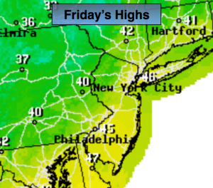
Today:
Clouds and sun, breezy and cooler. Highs in the mid 40s. West wind at 15-25mph with gusts to 30mph.
Tonight:
Partly cloudy and breezy. Lows in the lower to mid 30s in the City, the upper 20s inland. West wind at 10-20mph.
Saturday:
Partly cloudy with still above average temperatures. Highs in the mid 40s. The average high for this date is in the upper 30s.
Sunday:
Partly sunny, seasonal. Highs in the upper 30s.
Monday:
Mostly cloudy, colder. Chance of flurries or snow showers. Highs in the mid 30s.
Tuesday:
Mostly cloudy. Chance of flurries or snow showers. Highs in the mid 30s.
Stay Tuned.
Keep it here for a no nonsense, no hype forecast.