Synopsis:.
A cold front will swing through this morning with a few showers. The cold air will be delayed as it is a few hundred miles to the Northwest of the tri-state area. Because of this, another Spring-like day is expected under a mix of clouds and sun. The wind will be busy the next 24 hours. The mercury will come down is steps as we head into the weekend with no storms in sight.
A more Winter-like pattern looks to be in the cards as February nears. Will the storm track be favorable for snow? Right now I’m leaning toward no. Stay tuned.
Today:
Spotty morning showers otherwise, a mix of sun and clouds. Mild. Highs in the lower to mid 50s. Breezy. Southwest to West winds increasing to 15-25mph with gusts to 35mph later this afternoon.
Tonight:
Partly cloudy and breezy. Lows in the mid 30s in the City, near 30º inland. West wind at 15-25mph with gusts to 30mph.
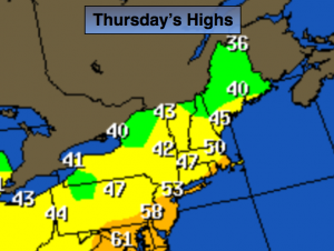
Friday:
Partly sunny, breezy and cooler. Highs in the mid 40s.
Saturday:
Partly sunny, more seasonal. Highs in the upper 30s.
Sunday:
Partly sunny. Highs in the upper 30s.
Monday:
Partly sunny, colder. Highs in the mid 30s.
Stay Tuned.
Keep it here for a no nonsense, no hype forecast.