Synopsis:
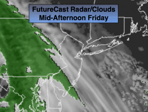
Today will start off with a mix of clouds and some sun. A weak warm front will throws showers our way by the afternoon. The rain will develop from West to East from 1pm to 4pm (FutureCast Radar/Cloud cover above).
The weekend looks to be a 50/50 split. Saturday will be the better of the two days with some of sun and once again mild readings. Clouds will dominate on Sunday and rain is likely later in the afternoon.
A large storm will affect the Eastern Seaboard later Sunday, Monday and into a part of Tuesday. Heavy rains and highs winds are possible. The latest computer guidance suggest that the system will emerge from the Southern states and then move up and off the coast. The pattern is garbage for any snow to fall in our tri-state area, key factors are missing. A more Winter-like pattern looks to be in the cards for the end of January and into February. Stay Tuned.
Today:
Mainly cloudy, a few peeks of morning sun. Showers will develop by during the afternoon. Highs in the mid 40s. Northeast to Southeast wind at 5mph.
Tonight:
Mostly cloudy. Lows around 40 in the City, near freezing well inland. Southeast to Southwest wind at 5mph.
Saturday:
Partly sunny and mild. Highs in the mid 50s.
Sunday:
Mostly cloudy. Light rain will work in during the afternoon. Highs in the mid 40s.
Monday:
Rain, heavy at times. Windy. Highs in the mid 40s.
Tuesday:
Rain will taper off during the afternoon. Highs in the mid 40s.
Stay Tuned.
Keep it here for a no nonsense, no hype forecast.