Synopsis:
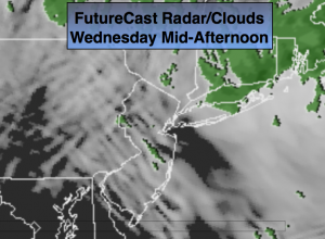
The low pressure system responsible for our wet weather will slowly move off the coast today. On and off showers and patchy fog is expected this morning. By later in the afternoon a bit of sun is possible over Western areas as the low moves farther off the coast (FutureCast Radar/Cloud-Cover map above).
High pressure will move into the region tomorrow and Friday. The sun will return. This high will give us a decent weekend with above average temperatures.
Looking ahead, a large storm will affect the Eastern Seaboard Monday into Tuesday with rain and possibly high winds. Like many of the storms this season mild air will be brought up from the Gulf and Southeast coast as the systems stays inland. A more Winter-like pattern looks to be in the cards for the end of January and into February. Stay Tuned.
Today:
Spotty showers morning showers and patchy fog. Some afternoon sun is possible over Western sections. Mild. Highs in the mid 40s. North wind at 8-12mph.
Tonight:
Mostly cloudy. Lows in the upper 30s in the City, the upper 20s inland. East wind becoming Northwest at mph.
Thursday:
Mostly sunny, Mild. Highs around 50º.
Friday:
Sun will give way to clouds. Readings will be about ten degrees above the normal. Highs in the mid to upper 40s.
Saturday:
Morning clouds, afternoon sun. Highs in the upper 40s.
Sunday:
Partly sunny. Highs in the mid 40s.
Stay Tuned.
Keep it here for a no nonsense, no hype forecast.