Synopsis:
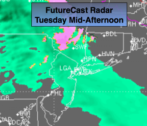
An area of low pressure that gave the parts of the midwest an ice storm will move into the Eastern Great Lakes today. Our area will be on the mild side of the system meaning rain. Spotty showers are expected this morning. The rain will become a bit more widespread later this afternoon (FutureCast radar above).
The low will move off the coast Wednesday with any leftover showers giving way to some afternoon sun. By late week high pressure will move in with more sunshine expected.
Looking down the pike the weather pattern will look more like Spring with a ridge of high pressure off the Southeast coast. This is not a pattern conducive to snow along the East coast. Mild temperatures are expected the next seven to ten days. A more Winter-like pattern looks to be in the cards for the end of January and into February. Stay Tuned.
Today:
Cloudy. Spotty showers this morning. More widespread rain developing this afternoon. Spotty freezing rain/drizzle well inland (this is a low chance). Highs in the mid 40s, 30s North and West. East to Southeast winds at 5-10mph.
Tonight:
Periods of rain, drizzle and fog. Lows in the lower 40s in the City, the 30s inland. East wind becoming Northwest toward sunrise at 5mph.
Wednesday:
Morning showers. Some afternoon sun is possible. Mild. Highs around 50º.
Thursday:
Partly sunny. Highs in the upper 40s.
Friday:
Sun will give way to clouds. Readings will be about ten degrees above the normal. Highs in the mid to upper 40s.
Saturday:
Morning showers, some afternoon sun. Highs in the mid 40s.
Stay Tuned.
Keep it here for a no nonsense, no hype forecast.