Synopsis:
Arctic high pressure will settle over the region today providing abundant sunshine but despite the bright conditions readings will remain below freezing. Once the high slips off the coast the return flow will bring up milder temperatures. In response to the approaching mild air clouds will increase Tuesday and a bit of spotty light snow, sleet or rain is possible during the afternoon. A January thaw is on the way for the rest of the week. Highs will be near 50º Wednesday through Friday. Say goodbye to the snow on the ground.
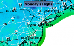
Today:
Sunny. Cold. Highs in the upper 20s. Northwest winds will become Southwest at 5-10mph.
Tonight:
Partly cloudy. Steady temperatures. Lows will be in the mid 20s in the City, the teens inland. Southwest winds at 5mph.
Tuesday:
Mostly cloudy, not as harsh. Spotty light snow, sleet or rain is possible in the afternoon mainly over the Northern half of the area. This won’t be a big deal (if it occurs at all). Highs in the 30s to around 40º.
Wednesday:
Morning showers, afternoon sun. Mild. Highs around 50º.
Thursday:
Partly sunny continued mild. Highs in the lower 50s.
Friday:
Partly sunny as the thaw continues. Highs in the lower 50s.
Stay Tuned.
Keep it here for a no nonsense, no hype forecast.