Synopsis:
The second punch this weekend will be the bitter blast. Despite plenty of sunshine temperatures today will remain well below freezing. Factor in the winds and the wind chill will be dangerously cold. We’ll be in the ice box through Monday. A January thaw will arrive by Tuesday and the snowmelt will begin.
Today:
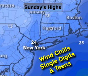
Mostly sunny and cold. Scattered afternoon flurries. Highs in the mid 20s. Wind chills in the single digits and teens. Northwest wind at 15-25mph with higher gusts.
Tonight:
Clear and frigid with diminishing winds. Lows in the mid teens in the City, the single digits inland. Northwest winds at 10-20mph and diminishing. Wind chills in the single digits.
Monday:
Sunny. Cold. Highs in the upper 20s.
Tuesday:
Sun will give way to clouds, mild. Highs in the lower to mid 40s.
Wednesday:
Morning showers, afternoon sun. Mild. Highs around 50º.
Thursday:
Partly sunny continued mild. Highs in the upper 40s.
Stay Tuned.
Keep it here for a no nonsense, no hype forecast.