Synopsis:
The storm that dropped anywhere from 10″ of snow in spots over Eastern Long Island to just a trace over the Northwestern counties will continue to pull away overnight. Snow, heavy at times over Eastern Long Island will come to an end by late evening. A frigid airmass will move in. Sunday will be the coldest day of the season so far. Wind chills will be harsh.
A January thaw will arrive by midweek and the snowmelt will begin.
Tonight:
Snow ends East, becoming mostly clear and frigid. Lows in the upper teens in the City, near 10º North and West wind chills near 0º. Northwest winds at 10-20mph.
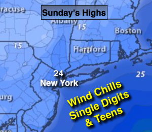
Sunday:
Mostly sunny and cold. Scattered afternoon flurries. Highs in the mid 20s. Wind chills in the single digits and teens. Northwest wind at 15-25mph with higher gusts.
Monday:
Sunny. Cold. Highs in the upper 20s.
Tuesday:
Sun will give way to clouds, mild. Highs in the lower to mid 40s.
Wednesday:
Morning showers, afternoon sun. Mild. Highs around 50º.
Thursday:
Partly sunny continued mild. Highs in the upper 40s.
Stay Tuned.
Keep it here for a no nonsense, no hype forecast.