Synopsis:
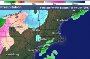
The high pressure system that gave us our bitter blast will slip off the coast today . The return flow will bring up milder temperatures. In response to the approaching mild air clouds will increase today and a bit of spotty light snow, sleet or rain is possible during the afternoon (this won’t be a big deal, map above). A period of rain is expected tonight. A January thaw is on the way as our flow will continue out of the Southwest through the end of the week. Say goodbye to the snow on the ground.
Looking down the pike, our next shot of wintry weather comes Saturday night and Sunday morning. A strong, cold high will be to our North and a warm front pushes in from the South. The potential is there for snow or a mix at night into Sunday morning. Stay tuned.
Today:
Mostly cloudy, not as harsh. Spotty light snow, sleet or rain is possible in the afternoon mainly over the Northern half of the area. This won’t be a big deal (if it occurs at all). Highs in the 30s to around 40º. South wind at 5-10mph.
Tonight:
Steadier rain will develop. Which may begin as a mix well inland. Steady to slowly rising temperatures. Lows will be in the 30s to around 40º. Southwest winds at 5mph.
Wednesday:
Partly sunny & mild. Highs in the lower 50s.
Thursday:
Partly sunny continued mild. Highs in the mid 50s.
Friday:
Partly sunny as the thaw continues. Highs in the lower 50s.
Saturday:
Increasing clouds. Colder. Highs in the mid 30s. Chance of snow or a mix at night.
Stay Tuned.
Keep it here for a no nonsense, no hype forecast.