Synopsis:
January has made it’s presence known. Temperatures today will be much colder than recent days. Highs will be near seasonal averages. Sun will give way to clouds as high pressure moves offshore.
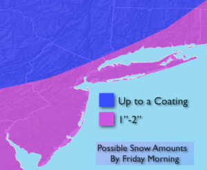
A bit of snow is expected to develop later this evening and into early Friday morning as a weak low pressure system moves up and off the coast. This will not be a significant snow. Most areas will receive a coating to two inches. The snow will end during the early morning commute.
A cold blast will move in for the weekend. Temperatures will remain below freezing. Another low will develop off the Carolina’s and move up and off the coast, sparing our region of any snow. The cold will be the top story.
Today:
Sun to clouds, colder. Highs in the mid 30s. Diminishing West wind at 10-15mph.
Tonight:
Light snow will develop between 9pm and midnight. Lows in the upper 20s in the City, near 20º inland. West wind at 5mph. A light accumulation of a coating to two inches is expected by sunrise (snow map above).
Friday:
Early morning light snow, otherwise becoming mostly sunny. Highs in the mid 30s.
Saturday:
Partly sunny and cold. Highs in the 20s to around 30º.
Sunday:
Mostly sunny and cold. Highs in the upper 20s.
Monday:
Sunny. Cold. Highs in the mid to upper 20s.
Stay Tuned.
Keep it here for a no nonsense, no hype forecast.