Synopsis:
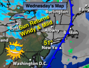
The low and cold front that caused the wet weather has moved off the coast. Any clouds will give way to sunshine. The cold air is displaced 200 miles West of the front. For this reason temperatures will very mild today. Winds will increase dramatically during the afternoon and much colder readings will be with us by tonight.
January will make it’s presence known by Thursday as temperatures will be near average. There is a chance of a bit of light snow or snow showers Friday morning. It doesn’t look to be a big deal as the sun will soon return. The cold temperatures will be the main story. Another low will move up and off the coast over the weekend. At this time it looks to remain offshore. None of the computer models have the storm affecting the area significantly at this time. Stay tuned.
Today:
Sun and clouds, mild. Highs around 50º. Becoming windy in the afternoon. West wind increasing to 15-25mph with higher gusts.
Tonight:
Clear to partly cloudy. Much colder. Lows in the mid to upper 20s in the City, near 20º inland. West wind at 15-25mph.
Thursday:
Partly sunny and much colder. Highs in the mid 30s.
Friday:
Mostly cloudy with a chance of snow showers in the morning, otherwise becoming partly sunny. Highs around freezing.
Saturday:
Partly sunny and cold. Highs around 30º. Eyes will be on a offshore storm.
Sunday:
Partly sunny and cold. Highs in the upper 20s to around 30º.
Stay Tuned.
Keep it here for a no nonsense, no hype forecast.