Synopsis:
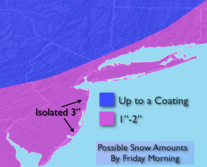
A bit of snow is expected to develop later this evening over the Western ‘burbs and around Midnight around the City and East as a weak low pressure system moves up and off the coast. This will not be a significant snow. Most areas will receive a coating to two inches. Isolated 3″ amounts are possible over Central NJ. The snow will end by sunrise for most. Eastern Long Island the flakes will quite by mid morning. The sun will return soon after with slightly below average temperatures.
Now, to the snow threat for coastal and Eastern areas on Saturday. The latest computer models have nudge the snow shield Northwest with the developing offshore storm. It’s a not a huge jog, but enough of a concern to include the potential of some snow for Coastal areas, possibly the City, and especially Long Island. Could a few inches fall out East. It’s a possibility, not a certainty. There a still a some time to fine tune this forecast. Just be aware of the potential. Farther inland skies clouds and some sun is expected.
The cold blast is the other top story for the weekend. Highs will be below freezing both days with lows in the teens.
Tonight:
Light snow will develop between 9pm and midnight. Lows in the upper 20s in the City, near 20º inland. West wind at 5mph. A light accumulation of a coating to two inches is expected by sunrise (snow map above).
Friday:
Early morning flakes east, otherwise becoming partly sunny. Highs in the mid 30s. Northwest wind at 8-12mph.
Saturday:
Mostly cloudy. A threat of some snow for the coast and Eastern areas. Highs in the mid 20s.
Sunday:
Mostly sunny and cold. Highs in the mid to upper 20s.
Monday:
Sunny. Cold. Highs in the upper 20s.
Tuesday:
Sun will give way to clouds, mild. Highs around 40º.
Stay Tuned.
Keep it here for a no nonsense, no hype forecast.