Synopsis:
Spring-like temperatures of Tuesday will be replaced by cooler readings today as high pressure works in.
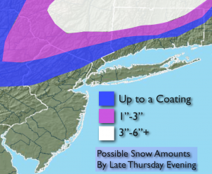
A more significant cold front will move toward the area by Thursday morning. The computer models develop a storm on the front. The analyzation of the latest guidance is a yawn for me with snow for our immediate area on Thursday. The system is moving way to fast and it is just too warm at the surface to support accumulating snow along the urban corridor and coast. Inland it should be cold enough for a coating of snow by late evening with a few inches possible over Lower NY State and interior CT. Possible snow amounts graphic above. Colder weather will move in to end the year.
Today:
Partly sunny with highs in the mid 40s. Northwest wind at 8-12mph.
Tonight:
Partly cloudy. Lows in the mid 30s in the City, the mid 20s inland. Winds becoming Southeast at 5-10mph.
Thursday:
Rain mixed with wet snow, especially inland. A period of wet snow is possible later in the afternoon and evening North and West. Highs in the lower 40s falling into the 30s by sunset.
Friday:
Partly sunny, windy and colder. Highs in the upper 30s.
Saturday:
Partly sunny. Cold. Highs in the upper 30s.
Sunday (New Year’s Day):
Partly sunny. Highs in the mid 40s.
Stay Tuned.
Keep it here for a no nonsense, no hype forecast.