Synopsis:
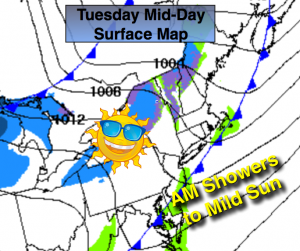
A moist Southerly flow ahead of a cool front will cause spotty showers this morning. Any showers will end by mid-day. The cold air is lacking behind the front. Temperatures will feel more like Spring as the sun returns.
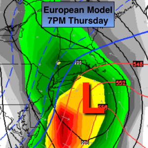
A more significant cold front will move toward the area by Thursday morning. Some of the computer models want to develop a wave of low pressure close the the region. The European map above taken verbatim is the most vigorous of the all the models. Taken verbatim, rain would go over to a period of snow with some accumulations all the way to the coast (not my forecast at this time, but stay tuned). Rain will develop Thursday morning. It should be cold enough for wet snow to be mix in and then a change to snow for a time, especially inland. A coating of snow is possible North and West of the City by late evening. Colder weather will move in to end the year.
Today:
Spotty showers through mid-day, becoming mostly sunny. Mild. Highs in the mid to upper 50s. Southwest to Northwest wind at 10-15mph with gusts to 25mph in the afternoon.
Tonight:
Mostly clear. Lows in the mid 30s in the City, the upper 20s inland. Northwest wind at 10-15mph.
Wednesday:
Sunny with highs in the mid 40s.
Thursday:
Rain mixed with wet snow, especially inland. A period of wet snow is possible later in the afternoon and evening. Highs in the lower 40s.
Friday:
Partly sunny. Colder. Highs in the upper 30s.
Saturday:
Partly sunny. Cold. Highs in the upper 30s
Stay Tuned.
Keep it here for a no nonsense, no hype forecast.