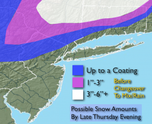
Synopsis:
***Use caution this morning North and West of the City as a thin glaze of ice has formed where temperatures are below freezing***A cold front will move toward the area today. A storm will develop on the front. Rain will develop in the morning. Wet snow is possible well inland. The system is moving way to fast and it is just too warm at the surface to support accumulating snow along the urban corridor and coast. Inland it should be cold enough for a coating of snow this morning before the changeover to rain. By late evening a few inches of snow is possible over Lower NY State and interior CT. Possible snow amounts graphic above. Colder weather will move in to end the year.
Today:
Morning wet snow/sleet North and West to the City may leave a coating of ice and snow before changing to rain otherwise, periods of rain elsewhere. A period of wet snow is possible later in the afternoon and evening North of the City which may leave a couple of inches. Highs in the lower 40s falling into the 30s by sunset. Southeast wind becoming Southwest and increasing to 10-20mph by later in the day.
Tonight:
Partly cloudy. Lows in the mid 30s in the City, the mid 20s inland. West winds at 15-25mph with higher gusts.
Friday:
Partly sunny, windy and colder. Highs in the upper 30s.
Saturday:
Partly sunny. Cold. Highs in the upper 30s.
Sunday (New Year’s Day):
Partly sunny. Highs in the mid 40s.
Monday:
Mostly cloudy with a chance of afternoon rain. Highs in the lower 40s.
Stay Tuned.
Keep it here for a no nonsense, no hype forecast.