Synopsis:
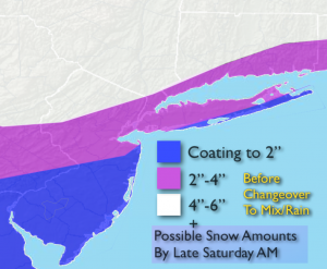
Snow will fall early this morning at a good intensity. The cold air wants to stick around as the warm front is having a hard time moving North with the Arctic air in place, for this reason I have upped snow amounts (map above). The snow will go over to rain along the coast and in the City by mid to late morning. There could be a prolonged period of ice North and West of the City, 1/10″ to 1/4″ of an inch of ice may accumulate. The precipitation will taper during the early afternoon.
The second punch will be an approaching cold front on Sunday. A wild temperature swing will occur this weekend. It’ll be the the tale of two seasons with Winter-like conditions this morning-cold and some snow to Spring-like conditions Sunday morning- temperatures rise into the 50s to near 60º ahead of the front! Rain and windy conditions are expected Sunday. The arctic front will move in during the afternoon and temperatures will again plummet. Hang on!
Today:
Snow early, changing to rain along the coast by mid-morning to late morning. A period of freezing rain is possible inland before the changeover. Temperatures will rise into the 40s by late day in the City to near 40º inland. Southeast to Southwest wind at 8-12mph.
Tonight:
Cloudy with areas of fog and drizzle. Temperatures will actually rise through the 40s and into the 50s at the coast. Readings will rise through the 30s and into the 40s inland. Southwest wind 8-12mph.
Sunday:
Cloudy, windy and warm with periods of rain developing later in the morning. Highs well into the 50s to around 60º during the morning. Temperatures will fall into the 30s and 40s during the afternoon.
Monday:
Partly sunny and cold once again. Highs only near freezing.
Tuesday:
Sunny and not as harsh. Highs in the mid to upper 3os.
Wednesday:
Partly sunny and seasonal. Highs in the mid 40s.
Stay Tuned.
Keep it here for a no nonsense, no hype forecast.