Synopsis:
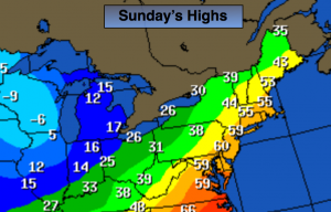
Our wild ride with the weather will continue. The second punch will be an approaching cold front today. A major temperature swing will occur this weekend (take a look at the difference in temps above between NYC and Chicago, wow)! It’ll be the the tale of two seasons with Winter-like conditions yesterday turning into Spring-like conditions by this morning- temperatures will rise into the 50s to near 60º ahead of the front! Today will start off with areas of fog. A Period of rain is expected with the front later this morning into mid-day. Skies will then remain mostly cloudy. Once the front move through early this afternoon temperatures will again plummet this afternoon. Readings will fall through the 40s and 30s. Cold but tranquil conditions will greet us for the beginning of the workweek. The next chance of precipitation looks to be later Thursday. It should be warm enough for just rain.
Today:
Cloudy, windy and warm with periods of rain developing later in the morning. Areas of fog early this morning. Highs will be well into the 50s to around 60º during the morning, except the 40s well inland. Temperatures will fall into the 30s and 40s during the afternoon. Southwest to Northwest wind at 15-30mph.
Tonight:
Mostly clear and much colder. Lows in the lower 20s in the City, the lower teens inland. Northwest wind at 15-25mph and diminishing.
Monday:
Partly sunny and cold once again. Highs only near freezing.
Tuesday:
Sunny and not as harsh. Highs in the mid to upper 3os.
Wednesday:
Partly sunny and seasonal. Highs in the mid 40s.
Thursday:
Morning sunshine with give way to clouds and late day rain. Highs in the mid 40s.
Stay Tuned.
Keep it here for a no nonsense, no hype forecast.