Synopsis:
High pressure will move over the region today. This will result in diminishing winds and sunshine that will give way to high clouds. It will be very cold with readings not getting above freezing.
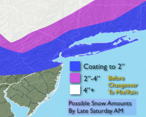
Our next precipitation maker will be late tonight and into the weekend. Frigid high pressure will be moving off the coast at the same time plenty of moisture will be working in from the South and West. The cold air will be hard to dislodge. Light snow should break out late tonight and continue into Saturday morning. Amazingly, the warm air will win the battle and the snow will change to rain along the coast and eventually inland as a warm front moves into the region. There could be a prolonged period of ice North and West of the City Saturday. Snow accumulations are expected mainly North and West of the City where several inches may fall before the changeover. The latest computer guidance suggest a weaker punch of snow and a slightly warmer atmosphere. This development has lower snow amounts for the region Saturday morning (map above).
The second punch will be an approaching cold front on Sunday. A wild temperature swing will occur this weekend. It’ll be the the tale of two seasons with Winter-like conditions Saturday morning-cold and some snow to Spring-like conditions Sunday morning- temperatures rise well into the 50s ahead of the front! Rain and windy conditions are expected Sunday. The arctic front will move in during the afternoon and temperatures will again plummet. Hang on!
Today:
Bitterly cold under mostly sunny skies (high clouds will work in during the afternoon). Highs in the mid 20s. Thankfully the wind will diminish . Northwest to Southwest wind at 8-12mph.
Tonight:
Thickening clouds with light snow developing after midnight. Temperatures will actually rise through the 20s to near freezing by morning along the coast. Inland, readings will rise through the teens and 20s. Southwest wind at 5mph.
Saturday:
Snow early, changing to rain along the coast. An accumulation is possible before the changeover. A period of freezing rain is possible inland before the changeover. Temperatures will rise into the 40s by late day in the City to near 40º inland.
Sunday:
Cloudy, windy and warm with periods of rain. Highs well into the 50s during the morning. Temperatures will fall into the 30s and 40s during the afternoon.
Monday:
Partly sunny and very cold once again. Highs only near 30º.
Tuesday:
Sunny and not as harsh. Highs in the mid to upper 3os.
Stay Tuned.
Keep it here for a no nonsense, no hype forecast.