Synopsis:
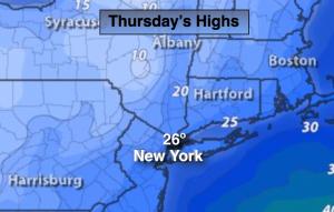
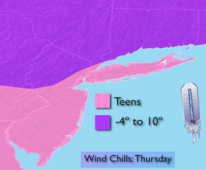
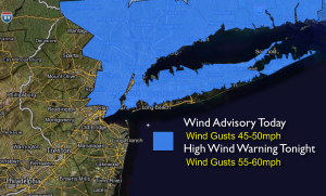
The Arctic Express has arrived and will be accompanied by the coldest air of the season so far. This cold will be dangerous. Wind chills will be in the teens along the coast to near 0º well inland Thursday (map above). Below zero wind chills are expected Thursday Night. Scattered snow showers and snow squalls are possible just about anytime into tonight. Any one of these squalls can drop a coating of snow in a very short period of time. Wind Advisories and High Wind Warnings have been posted for wind gust of 50mph-60mph later today and tonight.
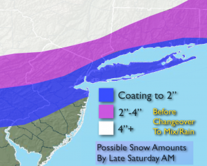
Our next precipitation maker will be Friday Night into the weekend. Frigid high pressure will be moving off the coast at the same time plenty of moisture will be working in from the South and West. The cold air will be hard to dislodge. Snow should break out Friday night and continue into Saturday morning. Amazingly, the warm air will win the battle and the snow will change to rain along the coast and eventually inland. There could be a prolonged period of ice North and West of the City Saturday. Snow accumulations are expected mainly North and West of the City where several inches may fall before the changeover.
A wild temperature swing will occur this weekend. It’ll be the the tale of two seasons with Winter-like conditions Saturday morning-cold and some snow to Spring-like conditions Sunday morning- temperatures rise well into the 50s! Another Arctic front will swing through Sunday afternoon. Temperatures will again plummet. Hang on!
Today:
Partly sunny, windy and very cold. Highs in the mid 20s in the City, the upper teens inland. Wind chills will be in the around zero to the single digits inland, the teens at the coast. Isolated snow squalls are possible. Winds Northwest at 15-35mph with gusts to 50mph.
Tonight:
Mostly cloudy with isolated snow squalls. A dusting is possible in spots. Lows in the mid teens in the city, the upper single digits inland. Northwest wind at 15-35mph with gusts of 45mph-60mph.
Friday:
Bitterly cold under mostly sunny skies. Highs in the lower to mid 20s. Wind Chills below zero in the morning. Thankfully the wind will diminish.
Saturday:
Snow early, changing to rain along the coast. An accumulation is possible before the changeover. A prolonged period of freezing rain is possible inland before the changeover. Temperatures will rise into the 40s by late day in the City to near 40º inland.
Sunday:
Cloudy, windy and warm with periods of rain. Highs well into the 50s during the morning. Temperatures will fall into the 30s and 40s during the afternoon.
Monday:
Partly sunny and very cold once again. Highs only near 30º.
Stay Tuned.
Keep it here for a no nonsense, no hype forecast.