Synopsis:
A cold front will move through the area Monday morning. A few showers are possible before sunrise. Skies will be bright the next several days. Much colder air will arrive tonight and stick around through Wednesday. Many areas will receive a frost and or freeze overnight midweek. The next threat of showers comes later Thursday with an approaching front.
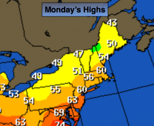
Today:
An early morning shower otherwise, mostly sunny, breezy and cool. Highs around 60º. Northwest wind increasing to 15-25mph with gusts to 30mph.
Tonight:
Mostly clear and much cooler than recent nights. Lows in the lower 40s in the City, the lower to mid 30s inland. Northwest winds at 10-20mph with higher gusts.
Tuesday:
Mostly sunny, breezy and much colder with highs in the lower 50s.
Wednesday:
Mostly sunny. Unseasonably cool. Highs around 50º.
Thursday:
Morning sun will give way to afternoon clouds. Chance of showers late. Highs in the mid 50s.
Friday:
Morning clouds will give way to mostly sunny skies. Highs around 60º.
Stay Tuned.
Keep it here for a no nonsense, no hype forecast.