Synopsis:
The storm responsible for our strong winds will continue to move into Eastern Canada. The winds will continue to be busy today (although not as strong as yesterday). Temperatures will be a few degrees below average but at least the sun will shine. Another cold front will move through the area Monday morning. A few showers are possible late tonight and early Monday. An even colder airmass will arrive this week. Many areas will receive a frost and or freeze overnight.
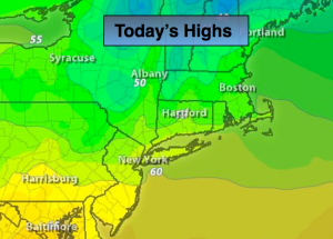
Today:
Mostly sunny, windy and cool with highs around 60º. The average high for this time of the year is 63º for Central Park. West wind at 15-30mph with higher gusts.
Tonight:
Becoming mostly cloudy with scattered showers after midnight. Lows in the lower 50s in the City, the lower 40s inland. West winds at 8-12mph.
Monday:
An early morning shower otherwise, mostly sunny, breezy and cool. Highs in the upper 50s to around 60º.
Tuesday:
Mostly sunny, breezy and much colder with highs in the lower 50s.
Wednesday:
Mostly sunny. Unseasonably cool. Highs around 50º.
Thursday:
Morning sun will give way to afternoon clouds. Chance of showers late. Highs in the mid 50s.
Stay Tuned.
Keep it here for a no nonsense, no hype forecast.