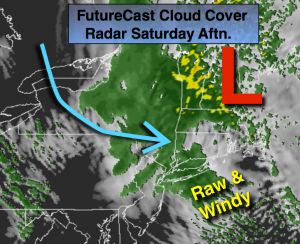
Synopsis:
A cold front and offshore storm will get their act together today. Scattered showers are likely on the backside of these systems through this afternoon. The storm will intensify rapidly as it moves into New England. Much colder air will filter in behind the storm on a strong Northwest wind (FutureCast Cloud-Cover and Radar above). A wind advisory has been posted for NYC and Long Island for wind gusts of 45-50mph today. Sunday will be fair and chilly with gusty winds.
Today:
Scattered showers. Windy and much colder. Highs will be in the lower to mid 50s. West/Northwest wind at 15-30mph with gusts to 45mph will make it feel like the 40s. Major shock to the body after experiencing temperatures in the 80s this week.
Tonight:
Clearing skies, windy and cold. Lows 35º-45º. West winds at 15-30mph with gusts to 45mph early, then diminishing some after midnight.
Sunday:
Partly sunny, windy and cool. Highs in the upper 50s to around 60º.
Monday:
Partly sunny and seasonal. Highs in the lower 60s.
Tuesday:
Partly sunny. Chilly. Highs in the mid 50s.
Wednesday:
Partly sunny. Cool. Highs in the mid 50s.
Stay Tuned.
Keep it here for a no nonsense, no hype forecast.