Synopsis:
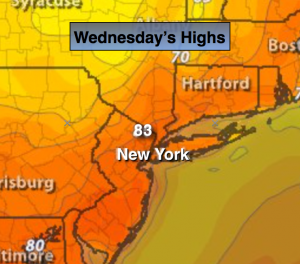
On more day of June-like readings is expected today as high pressure well off the coast continues to bring up very warm air for this time. Temperatures will once again be in the 80s away from the coast. Many record highs were established yesterday and more record highs are likely today. The record for Central Park for today is 83º set in 1963.
A cool front will slip to our South tonight and Thursday. Temperatures will drop significantly tomorrow. A more potent cold front will move through this weekend ushering in very chilly temperatures on strong winds. Get ready, a reality check is on the way.
Today:
Partly sunny and very warm. Highs in the lower to mid 80s. The record high is 83º set in 1963 for Central Park. Winds becoming Northwest at 5-10mph.
Tonight:
Partly cloudy. Lows around 60º in the City, near 50º inland. Northeast wind at 5-10mph.
Thursday:
Mainly cloudy with spotty showers, much cooler with highs in the upper 60s.
Friday:
Mostly cloudy with scattered showers. Highs around 70º.
Saturday:
Partly sunny. Windy. Highs will only be around 60º. Winds will gusts up to 40mph.
Sunday:
Partly sunny, breezy and unseasonably cool. Highs in the upper 50s.
Stay Tuned.
Keep it here for a no nonsense, no hype forecast.