Synopsis:
High pressure will be off the coast through midweek. The return Southwesterly flow will bring up very warm air for this time of the year through Thursday. These warm readings said hello on Monday (many areas got into the 80s) and will be with us through midweek. Record high temperatures are likely today and possibly on Wednesday. The record for Central Park for today is 82º set in 1928. These readings are more typical for mid to late June!
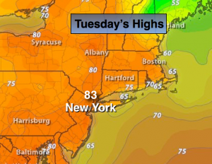
Today:
Mostly sunny and very warm. Highs in the lower to mid 80s. The record high of 82º set in 1928 is in jeopardy. Southwest wind at 10-15mph with higher gusts.
Tonight:
Partly cloudy and warm. Readings will be higher than the normal high for the day. Lows in the upper 60s in the City, 60º-65º inland. Southwest wind at 5-10mph.
Wednesday:
Mostly sunny and very warm. Highs in the lower 80s. The record high is 83º set in 1963 for Central Park.
Thursday:
Clouds and sun with spotty showers. Highs in the mid 70s.
Friday:
Mostly cloudy with scattered showers. Cooler. Highs in the upper 60s.
Saturday:
Partly sunny. Windy. Highs will only be in the lower 60s; it will be a reality check.
Stay Tuned.
Keep it here for a no nonsense, no hype forecast.