Synopsis:
High pressure will move off the coast. The return Southwesterly flow will bring up very warm air for this time of the year through Thursday. A bubble of 80’s is located in the mid-section of the country. These warm readings are headed toward our area Temperatures maybe fifteen degrees or more above normal by tomorrow and Wednesday- reaching 80º or above. These readings will be flirting with record highs and are more typical for mid to late June!
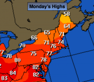
Today:
Clouds and sun. A spotty sprinkle can’t be ruled out. Much warmer. Highs in the mid 70s. Southwest wind at 5-10mph.
Tonight:
Partly cloudy and warm. Readings will be higher than the normal high for the day. Lows in the mid to upper 60s in the City, near 60º inland. Southwest wind at 5mph.
Tuesday:
Mostly sunny and very warm. Highs in the lower 80s. The record high is 82º set in 1928 for Central Park.
Wednesday:
Mostly sunny and very warm. Highs in the lower 80s. The record high is 83º set in 1963 for Central Park.
Thursday:
Partly sunny and warm. Highs in the mid 70s.
Friday:
Mostly cloudy with scattered showers. Cooler. Highs in the mid to upper 60s.
Stay Tuned.
Keep it here for a no nonsense, no hype forecast.