Synopsis:
An area of high pressure will sit over the Northeast for the rest of the week. Sunny and pleasant conditions are expected through Friday. Temperatures will be above normal- in the 70s.
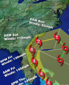
Hurricane Matthew is a catastrophic category 4 storm with winds of 140mph. The Northwest Bahamas will feel the wrath of Matthew through Friday and very likely a damaging scenario is will occur for the island chain (map below). The potential track continues to take the storm to the coast of Florida and the Southeastern States North to North Carolina Thursday through Saturday. A direct hit in any of these states remains to be seen. But nonetheless, Hurricane Warnings are up for the East coast of Florida from Ft. Lauderdale North to Edisto Beach, South Carolina. This area has a high chance of seeing damaging winds. The Western Atlantic high pressure will keep the hurricane from going out to sea for Florida . The trough never looked sharp enough to have Matthew ride up the Mid-Atlantic or Northeast coast. Nearly all the computer models have the storm making a sharp right hand turn out to sea or swing it back around doing a loop to the South Sunday into early next week. Only a few scattered showers are expected late Saturday with the trough swinging through with its accompanied cold front.
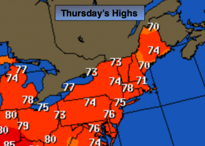
Today:
Sunny, warm. Highs in the mid 70s. Northeast to Southeast wind at 5mph or less.
Tonight:
Clear and Chilly. Lows around 60º in the City, the lower 40s inland. East wind at 5mph or less.
Friday:
Sunny. Highs in the lower 70s.
Saturday:
Partly Sunny. A spotty late day shower is possible. Highs in the upper 60s.
Sunday:
Mostly sunny, breezy and cool with highs in the mid 60s.
Monday:
Sunny and cool with readings in the mid 60s.
Stay Tuned.
Keep it here for a no nonsense, no hype forecast.