Synopsis:
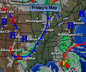
An area of high pressure will sit over the Northeast today. Sunny and pleasant conditions are expected. Temperatures will be above normal- in the 70s.
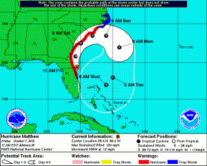
Hurricane Matthew is category 3 storm with winds of 115mph. The hurricane continues to parallel the Northeast coast of Florida, just offshore. Hurricane force wind gusts are likely from Daytona and to the North as the hurricane makes its closest approach the coast. Hurricane Warnings are up for the East coast of Florida from Cocoa Beach, Fl, North to Surf City, South Carolina. Matthew will continue to slowly weaken. The Western Atlantic high pressure will keep the hurricane from going out to sea for Florida . But once it’s at the latitude of Georgia it will start it’s curvature to the East. How sharp of a curvature will determine if the Georgia through North Carolina coast line will see hurricane force winds or tropical storm force winds. The storm will affect this region over the weekend. The trough never looked sharp enough to have Matthew ride up the Mid-Atlantic or Northeast coast. A possible loop of the hurricane will occur well off the coast.
Only a few scattered showers are expected around here late Saturday with the trough swinging through with its accompanied cold front. Fall will be in here in full force Sunday with cooler and breezy conditions.
Today:
Sunny. Highs in the mid 70s. East to Southeast wind at 5-10mph.
Tonight:
Clear early, becoming mostly cloudy late. Lows near 60º in the City, the mid 40s inland. Light East wind.
Saturday:
More clouds than sun. A spotty afternoon shower is possible. Highs in the upper 60s.
Sunday:
Mostly sunny, breezy and cool with highs in the mid 60s.
Monday:
Sunny and cool with readings in the lower to mid 60s.
Tuesday:
Sunny and seasonal with readings in the mid 60s.
Stay Tuned.
Keep it here for a no nonsense, no hype forecast.