Synopsis:
An area of high pressure will move in from Eastern Canada for the rest of the week. Sunny and pleasant conditions are expected through Friday.
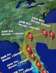
Hurricane Matthew is now a category 3 storm with winds of 120mph. The Bahamas will feel the wrath of Matthew into late week-a prolonged and very likely a damaging scenario is setting up for the island chain (map below). The hurricane could strengthen once again to category 4 status. Will the storm strike the East coast? The potential has increased that the storm will most likely graze the coast of Florida and the Southeastern States North to North Carolina Thursday through Saturday. A direct hit in any of these states remains to be seen. The Western Atlantic high pressure will keep the hurricane from going out to sea. Once it get to the latitude of the Outer Banks will it turn out to see or will in continue up the coast? As I’ve been stating all along; the trough never looked sharp enough to have Matthew ride up the Mid-Atlantic or Northeast coast. Nearly all the computer models have the storm making a sharp right hand turn out to sea or swing it back around to the South Sunday into early next week. The threat of a coastal front setting up is slight at best and the thinking now is only a few scattered showers are expected late Saturday with the trough swinging through with its accompanied cold front.
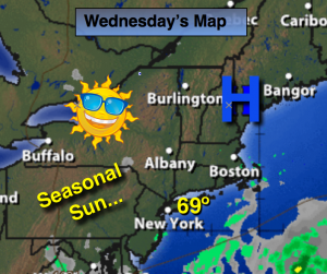
Today:
Sunny. Highs in the upper 60s. Northeast wind at 5-10mph.
Tonight:
Clear and Chilly. Lows in the mid 50s in the City, the lower 40s inalnd. Northeast wind at mph.
Thursday:
Sunny, warm. Highs in the mid 70s.
Friday:
Sunny. Highs in the lower 70s.
Saturday:
Partly Sunny. A spotty late day shower is possible. Highs in the upper 60s.
Sunday:
Mostly sunny, breezy and cool with highs in the mid 60s.
Stay Tuned.
Keep it here for a no nonsense, no hype forecast.