Synopsis:
The heat wave that many areas have experienced the last three days has ended. Central Park and other areas in the immediate NYC vicinity and to the East did not have three consecutive days of 90º or higher which means technically, there wasn’t a heat wave . Much of New Jersey did officially record a heat wave. No matter how you slice it- uncomfortable, was the adjective to describe the weather.
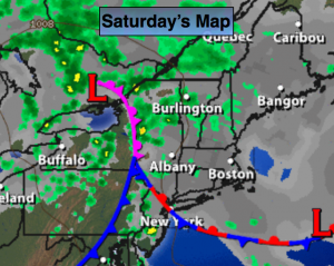
This weekend will be much cooler as a weak low and stationary front drapes South of NYC. This will keep an onshore flow over much of the region. To the South it will be soupy and more unstable. These elements will provide mainly grey skies and scattered storms on Saturday. The storms are most likely later in the day on Saturday.
On Sunday an upper low over New England may pinwheel some energy into the region resulting in isolated storms. Much of the day will be dry. It’ll definitely be the better half of the weekend.
Looking down the pike, the heat will return mid to late week next week.
Today:
Much cooler and less humid with highs only in the 70s throughout the region. Clouds will dominate much of the day and there will be times of showers and drizzle. Scattered storms are once again possible during the afternoon and evening. Some of the storms may turn severe over Western areas. Once again keep an eye to the sky for threatening weather after 3PM. Northeast wind at 8-12mph.
Tonight:
Scattered showers and isolated storm early, otherwise mostly cloudy. Lows in the 60s. East wind at 5mph.
Sunday:
Partly sunny with isolated storms. Most areas will remain rain-free. Highs around 80º.
Monday:
A July gem. Sunny and warm with low humidity. Highs in the mid 80s.
Tuesday:
Mostly sunny and warm with increasing humidity. Highs in the upper 80s.
Wednesday:
Hazy, hot and humid with readings around 90º.
Keep it here for a no nonsense, no hype forecast.