Synopsis:
A disturbance in this hot airmass will affect the area later this afternoon and evening with scattered storms. The heat will break on Saturday (meaning not hitting 90º). Temperatures will be some ten degrees cooler. It’ll still be humid with scattered storms during the afternoon.
A less humid airmass will arrive for the second half of the weekend.
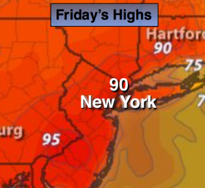
Today:
One more hot and humid day. Under hazy skies readings will be around 90º. Scattered thunderstorms will be around during the afternoon. Keep an eye to the sky for threatening weather after 2PM. Northeast to Southeast wind at 8-12mph with gusts to 20mph.
Tonight:
Scattered evening storms. Partly cloudy and muggy. Lows in the lower 70s in the City, the upper 60s inland. Southeast to East wind at 5mph.
Saturday:
The heat wave will break. Much cooler with highs only around 80º. Clouds will dominate with high humidity. Scattered storms are once again possible during the afternoon.
Sunday:
The humidity breaks with highs in the mid 80s under mostly sunny skies.
Monday:
A July gem. Sunny and warm with low humidity. Highs in the mid 80s.
Tuesday:
Mostly sunny and warm with increasing humidity. Highs in the upper 80s.
Keep it here for a no nonsense, no hype forecast.