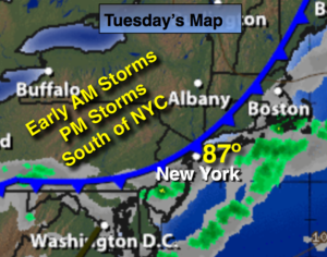
Synopsis:
A weak cool front will move through the area today with spotty storms, much of the time will be dry. A slightly cooler airmass will move in for mid to late week. An area of low pressure will bring showers and thunderstorms Thursday. High pressure will move in for the weekend providing abundant sunshine.
Today:
Spotty storms early this morning, otherwise partly sunny and warm. Scattered afternoon storms are possible especially South of the City. Highs in the mid to upper 80s. West Southwest wind at 5-10mph
Tonight:
An isolated evening thunderstorm, otherwise partly cloudy. Lows in the mid 60s in the City, the mid 50s inland. Winds becoming Northwest at 5-19mph.
Wednesday:
Mostly sunny with low humidity. Highs in the mid 80s.
Thursday:
Mostly cloudy with scattered showers and thunderstorms with readings in the mid to upper 70s.
Friday:
Partly Sunny with with highs around 80º.
Saturday:
Sunny and warm with readings in the mid 80s.
Stay Tuned.
Keep it here for a no nonsense, no hype forecast.