Synopsis:
A ridge of high pressure will result in a midweek delight for the tri-state area. An area of low pressure will bring showers and thunderstorms Thursday. The punch with this system looks to take a more Southern track, if this is the case, the severe weather threat will be kept to a minimum and confined to Southern regions. High pressure will move in for the weekend providing abundant sunshine.
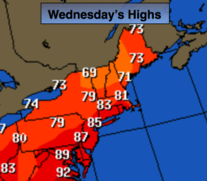
Today:
Mostly sunny with low humidity. Highs in the mid 80s. Northwest wind at 10-20mph.
Tonight:
Becoming mostly cloudy. A few showers are possible toward dawn. Lows in the upper 60s in the City, the mid 50s inland. Winds Northwest to East at 5mph.
Thursday:
Mostly cloudy with scattered showers and possibly a thunderstorm. Highs in the mid to upper 70s.
Friday:
Mostly sunny with readings in the mid 80s.
Saturday:
Sunny with highs in the mid 80s.
Sunday:
Sunny and warm with readings in the mid to upper 80s.
Stay Tuned.
Keep it here for a no nonsense, no hype forecast.