Synopsis:
High pressure off the East coast will result in a warm to hot day today. A weak cool front will move through the Tuesday morning. A slightly cooler airmass will move in for mid to late week. An area of low pressure will bring showers and thunderstorms Thursday.
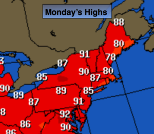
Today:
Sunny and warm. Highs in the mid to upper 80s. Cooler at the coast. Southeast to South wind at 8-12mph. Summer arrives at 6:34pm. At this time the sun direct rays are at the farthest Northern point in the Northern hemisphere, at the Tropic of Cancer- 23.5ºN.
Tonight:
Mostly cloudy with scattered showers and possibly a rumble of thunder after midnight. Lows near 70º tin the City, the mid 60s inland. Southwest to West wind at 5-10mph.
Tuesday:
Spotty morning showers otherwise partly sunny and warm. Highs in the mid to upper 80s.
Wednesday:
Mostly sunny. Highs in the mid 80s.
Thursday:
Mostly cloudy with scattered showers and thunderstorms with readings in the upper 70s.
Friday:
Sunny with with highs around 80º.
Stay Tuned.
Keep it here for a no nonsense, no hype forecast.