Synopsis:
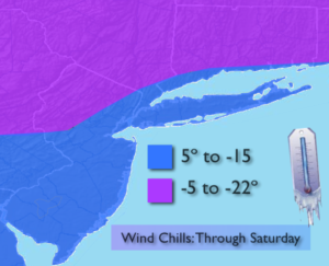
The coldest air of the season so far will be with us through the weekend. Arctic air will continue to spill in on strong Northwest winds between the storm in Eastern Canada and a strong area of high pressure heading in from Central Canada. The winds will make it even that more dangerous. Winds will gust up to 35mph. Wind chills will make it feel well below zero at times. Please dress in layers, cover any exposed skin and check in on the elderly and keep an eye on your pets.
The High pressure will provide a partly sunny sky despite the numbing cold.
Tranquil, but frigid conditions are expected right through the weekend.
There is light at the end of the tunnel-temperatures will rise above freezing early next week. This will be the first time above the freezing mark since Christmas Day.
Stay tuned.
Today:
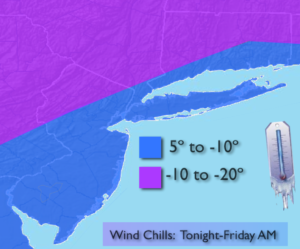
Partly sunny, windy and bitterly cold. Highs 8º to 15º above. Winds West to Northwest at 15-30mph with gusts to 40mph. Wind chills 5º to -20º.
Tonight:
Clear and frigid. Lows -3º to 4º above. Northwest winds at 15-30mph with gusts to 35mph. Wind chills -5º to -22º.
Saturday:
Partly sunny and bitterly cold. Highs within a few degrees of 10º.
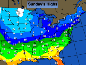
Sunday:
Mostly sunny and cold. Highs in the upper teens.
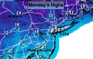
Monday:
Mostly cloudy with a chance of late day light snow. Highs in the mid 30s.
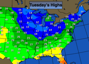
Tuesday:
Partly sunny. Highs in the upper 30s.
Keep it here for a no nonsense, no hype forecast.