Synopsis:
A January thaw will be with us through early Saturday morning.
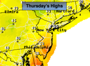
High pressure will dominate through today with tranquil conditions and readings well above freezing. The return flow around the high will allow the mercury to reach the lower 50s. The average high is 38º.
A significant ridge will develop with the jet stream this will allow a Southerly flow to develop ahead of the front and storm system. Very warm air will work up from the South on Friday. Periods of rain is expected. Some of the rain will be heavy Friday morning. Snow melt for sure.
On Saturday a second low pressure will move up the Piedmont. The latest computer guidance has the storm a bit closer to the coast. Rain is likely Saturday morning. The temperature gradient from the immediate coast to 150 miles North and West is extreme-from the 50s to the 20s. If the low is far enough East the cold air will spill into the Northwestern suburbs and allow for a freezing rain situation. This has to monitored very closely. Whatever the case the precipitation will end Saturday afternoon with temperatures falling into the 20s and 30s by late day.
Colder times are in our future beyond this time frame and there is a snow threat next week. Enjoy the break now!
Stay tuned.
Thursday:
Mostly cloudy. Mild. Highs in the lower to mid 50s. South wind at 5mph.
Tonight:
Cloudy and very mild. Areas of light rain or drizzle is possible after midnight. Lows in the 50s in the City, the 40s inland. Southeast wind at 5mph.
Friday:
Periods of rain. Balmy. Highs in the lower 60s.
Saturday:
Periods of rain in the morning. Freezing rain is possible inland. The sun may make an appearance by mid to late afternoon. A morning high of 50º with readings falling into the 30s along the coast, the 20s inland during the afternoon.
Sunday:
Partly sunny, breezy and much colder. Highs around freezing.
Monday:
Partly sunny, breezy and colder. Highs near 30º.
Keep it here for a no nonsense, no hype forecast.