Synopsis:
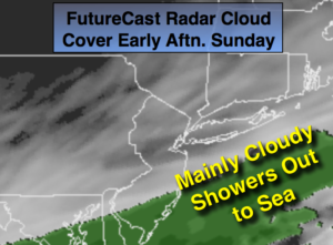
Mild readings will continue through the weekend. Showers are likely this morning as a weak cold front passes through but clouds should hang tough through the afternoon. A bit of dim sun is possible.
Two storms will pass our latitude early next week.
Storm #1 will develop off the coast on Monday. This system should be far enough offshore to spare the area precipitation. Clouds will win the battle against the sun.
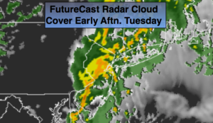
Storm #2 will develop Monday night and Tuesday off the Mid-Atlantic coast. At the same time dynamic jet stream will move into the area. A low threat of a period of light snow or snow showers is in the forecast, not from the offshore low, but another feature that some of the computer models are hinting at- a trough of low pressure extending to the West of the departing storm on Tuesday. Where this trough sets up will determine who will see the light snow or snow showers from this feature. This will not be a big deal.
Tranquil conditions are expected midweek.
The next threat of snow is Friday.
Stay tuned.
Today:
Scattered morning showers otherwise mostly cloudy during the afternoon. Mild. Highs in the lower 50s. West to North winds at 5-10mph.
Tonight:
Mostly cloudy. Lows in the mid 30s in the City, the upper 20s to around freezing inland. North to Northeast winds at 5-10mph.
Monday:
Mostly cloudy, cooler. Highs in the lower 40s.
Tuesday:
Mostly cloudy with a low threat of light snow or snow showers. Highs around freezing.
Wednesday:
Mostly sunny and cold. Highs around freezing.
Thursday:
Partly sunny. Highs in the lower 40s.
Keep it here for a no nonsense, no hype forecast.