Synopsis:
Today will be a gem as high pressure dominates off the coast. Mostly sunny skies with readings just above average is expected. The average high for the date is 81º.
Humidity and the threat of showers and storms returns Friday as a moist Southerly flow develops ahead of a slowly moving cool front.
The weekend looks like a 50/50 split. Scattered showers and storms are expected Saturday as the front slowly moves through the region. The second half of Saturday may turn out dry with some sun later in the day. Sunday will be the better half of the weekend with plenty of sunshine and low humidity.
Stay tuned.
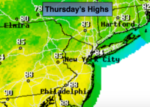
Today:
Mostly sunny with low humidity. Highs in the lower to mid 80s. Winds becoming South at 8-12mph.
Tonight:
Becoming mostly cloudy and muggy by morning. Lows in the lower 70s in the City, the 60s inland. South/Southwest winds at 5-10mph.
Friday:
Mostly cloudy and more humid with scattered showers and thunderstorms. There will be dry times. Highs in the lower to mid 80s.
Saturday:
Scattered showers and thunderstorms through mid-day. Some late day sun. Humid. Highs in the lower 80s.
Sunday:
Partly sunny. Highs in the lower 80s.
Monday:
Partly sunny. Slight chance of an afternoon storm. Highs in the upper 70s.
Keep it here for a no nonsense, no hype forecast.