Synopsis:
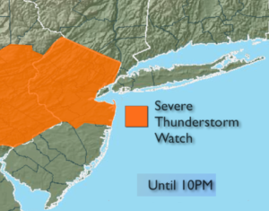
***SEVERE THUNDERSTORM WATCH is in effect until 10pm for Northern & Central NJ. A watch means that conditions are favorable for the formation of severe thunderstorms. Severe thunderstorms contain winds in excess of 58mph and or 1″ hail. The watch is in effect until 10pm***
A very warm and humid airmass will over the region through Saturday morning. A cool front will approach the region along with a weak disturbance. Showers and thunderstorms are possible tonight and Saturday morning. Some of the rainfall could be heavy.
The weekend looks like a 50/50 split. Scattered showers and storms are expected Saturday as the front slowly moves through the region. The second half of Saturday will feature sunshine and lowering humidity. Sunday will be the better half of the weekend with plenty of sunshine and low humidity.
Stay tuned.
Tonight:
Scattered showers and thunderstorms. Muggy. Lows 70º-75º. South/Southwest winds at 8-12mph.
Saturday:
Scattered showers and thunderstorms through mid-day. Afternoon sun. The humidity will decrease. Highs in the mid 80s. West winds at 10-15mph.
Sunday:
Mostly sunny. Highs in the lower 80s.
Monday:
Partly sunny. Highs in the upper 70s.
Tuesday:
Sun and clouds. Spotty showers. Highs in the mid to upper 70s.
Wednesday:
Mostly sunny. Highs in the lower 80s.
Keep it here for a no nonsense, no hype forecast.