Synopsis:
March is coming in like a lion. Three systems will have affected the area by Monday with snow threats. The first is this morning, the second will be tonight into Saturday, and the last punch will be Sunday night and Monday morning. The potential snow amounts will increase with each system.
Weak disturbance (system #1) will skirt the area from the South this morning. Light snow will taper off from West to East this morning. A coating to an inch is possible. Up to two inches of snow may accumulate over Ocean county. Skies will remain mostly cloudy for the first day of March.
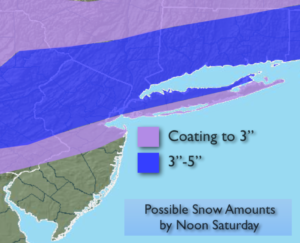
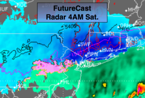
System #2 will affect the area tonight and Saturday morning as a low develops off the coast. The latest computer models have this system more robust. Snow/mix or rain will develop this evening. South of the City it looks like more of a mix or rain. In the NYC vicinity-a few inches may fall by morning. Inland areas and to the North and East several inches of snow may accumulate. I will get a potential snowfall map out this afternoon. Please be aware that many will have difficult traveling Saturday. The low will pull away and leave the area with scattered light precipitation during the afternoon as skies remain mostly cloudy.
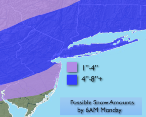
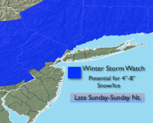
Sunday will start off with sun, but clouds will increase and thicken during the day. A storm will track up from the South (system 3). Light rain will develop during the afternoon along the coast. North and West it’ll be snow or a mix. The latest computer guidance has the storm track farther to the South- a slightly colder solution. The track of the storm looks to run now from Richmond VA to just East of Eastern Long Island. The storm will be progressive, meaning it’ll move quickly. The storm is also loaded with moisture. A shot of moderate to heavy precipitation is expected for 6 hours Sunday night. The million dollar question is where will the rain, snow line setup? At this point in time areas North and West of NYC have the best chance of seeing significant snow. Closer to the coast it’ll be just warm enough for a mix, but I can’t rule out a changeover to snow here either. The storm will move away early Monday with any snow or mix ending during the early morning. Stay tuned.
Keep it here for a no nonsense, no hype forecast.
Today:
Early morning light snow, otherwise remaining cloudy. Highs around 40º. Northeast to East winds at 5-10mph.
Tonight:
Snow, mix, rain developing. Lows around freezing in the city, the upper 20s inland. Northeast winds at 5-10mph, increasing to 10-20mph late by the coast.
Saturday:
Morning snow or a mix. Remaining cloudy. Highs around 40º.
Sunday:
Morning sun, otherwise thickening clouds with light rain, mix or snow developing during the afternoon. Highs in the lower 40s. At this time, rain or a mix is possible at the coast at night. Snow, mix is possible inland. Significant accumulations are possible where the precipitation stays mostly snow (think inland).
Monday:
Early morning snow/mix, otherwise party sunny, wind and cold. Highs in the mid 30s.
Tuesday:
Partly sunny, breezy and cold. Highs around 30º.