Synopsis:
A stationary front will move North and South over the next 4 days. When the front shifts to the North temperatures will pop into the 70s (near 80º today) and when it settles South of the region readings will be very cool. Needless to say we are on a rollercoaster ride-hang on.
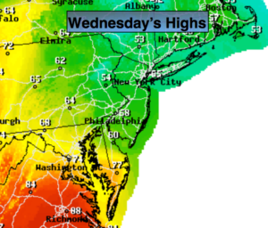
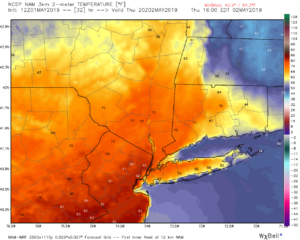
The wind will turn to the West for a time as the front moves to our North today. Clouds and fog will break for some sun. This will allow very warm area to work up from the Mid-Atlantic. Readings will rise well into the 70s to around 80º in many areas with the exception being areas to the North and East of the City (here the wind will still be off the cold Atlantic, 2nd map above). An afternoon thunderstorm can’t be ruled out.
Cooler readings and the chance of showers is the forecast for Friday as the stationary front slips just to the South.
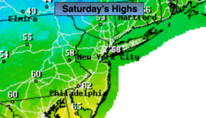
The better day of the weekend looks to be Saturday. The wavy front will inch back to the North. Any showers will end Saturday morning. The sun will return. Temperatures will again pop into the lower 70s. By Sunday a storm will develop over Western Virginia and move just South of the City. Rain is likely. Some of the rain maybe heavy. We may be able to squeak out of few hours of dry time later Sunday afternoon- don’t hold your breath.
Stay tuned.
Keep it here for a no nonsense, no hype forecast.
Today:
Clouds giving way to some sun. Much warmer. Chance of a late day thunderstorm. Highs getting well into the 70s to near 80º from the City and to the West. The exception will be Eastern areas where highs will remain in the upper 50s and 60s. West wind for most areas at 5-10mph. Winds will be out of the Northeast over parts of Long Island and Connecticut.
Tonight:
Mostly cloudy. Early showers will give way to spotty drizzle. Lows around 50º. East winds at 5-10mph.
Friday:
Mostly cloudy with scattered showers. Much cooler. Highs near 60º.
Saturday:
Morning showers, otherwise becoming partly sunny and warm. Highs in the lower 70s.
Sunday:
Rain likely. Highs in the upper 50s.
Monday:
Mostly sunny. Highs in the upper 60s.