Synopsis:
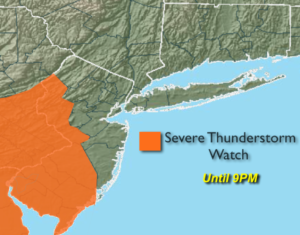
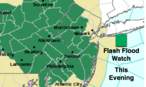
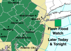
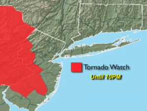
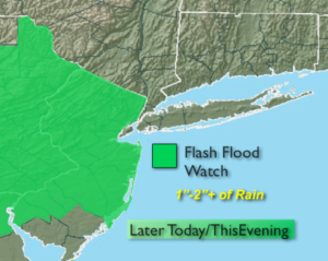
Scattered showers with a few thunderstorms with torrential rain will begin to taper off later this evening. A Flash Flood Watch remains in effect through the evening. The ground is completely saturated. Any additional rain will cause flooding. Please don’t drive through flooded roadways. You don’t know how deep the water is. Turn around, don’t drown.
The front will move through tonight and bring an end to the duck weather we have been experiencing. Friday and Saturday will be rain-free with the sun dominating as weak high pressure settles along the East coast. There is a chance of shower on Sunday with an approaching cool front.
Monday and Tuesday will be bright and cool for the beginning of June.
Keep it here for a no nonsense, no hype forecast.
Tonight:
Showers and storms with areas of torrential rain this evening. The rain will taper off later in the evening, otherwise, it’ll become partly cloudy overnight. Lows in the lower 60s in the City, the upper 50s inland. Winds becoming Northwest at 5-10mph.
Friday:
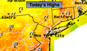
Mostly sunny, warm and less humid. Highs around 80º.
Saturday:
Partly sunny. Highs around 80º.
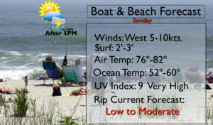
Sunday:
More clouds. A chance of showers. Highs in the mid 70s.
Monday:
Partly sunny, cooler and breezy. Highs in the upper 60s.
Tuesday:
Mostly sunny. Highs in the lower 70s.