Synopsis:
The weather will continue to cooperate for Memorial Day Holiday Weekend with one hiccup. A front just to our North will allow a bubble of hot air to work in today under a mix of sun and clouds. It will definitely feel like Summer with readings well into the 80s to around 90º. That same front will move South later today and this evening. Scattered showers and thunderstorms are possible. Please keep an eye to the sky after 4PM first over Northwestern areas then the storms will push toward the coast by evening.
Memorial Day will be memorable. A refreshing airmass will work in from the North. It’ll become mostly sunny with highs around 80º.
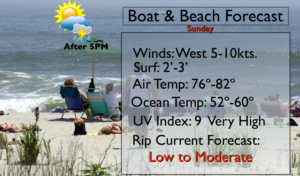
For those hitting the beach please don’t forget to slather on the sunscreen. The UV index is a very high 9. If you are fair skinned you will burn within 15 minutes without protection. I wouldn’t stick my big toe in the ocean as the water temperatures are only in the 50s.
The back to work and school forecast will be much cooler with scattered showers and storms. Warmer times are once again back by midweek.
Have a safe, happy Holiday!
Keep it here for a no nonsense, no hype forecast.
Stay tuned.
Today:
Partly sunny, becoming hot and more humid. Scattered late day showers and storms. Highs in the upper 80s. Cooler at the coast. West winds at 8-12mph.
Tonight:
Scattered early showers and storms, otherwise partly cloudy. Lows in mid 60s in the City, the upper 50s inland. Northwest to North winds at 5mph.
Memorial Day:
Mostly sunny, less humid. Highs around 80º.
Tuesday:
Mostly cloudy. Much cooler. Scattered showers and storms. Highs in the lower 70s.
Wednesday:
Partly sunny, warm. Highs in the lower 80s.
Thursday:
Partly sunny, very warm and humid. Scattered afternoon storms possible. Highs in the upper 80s.