Synopsis:
A bit of light rain or freezing rain is possible this morning. Slick spots are possible in areas that are below freezing. Temperatures will pop by afternoon to several degrees above the average high of 40º. Clouds will dominate and much of the afternoon with areas of light rain tapering off.
Tonight skies will clear as drier air works in from the West.
Thursday will be seasonal as another front moves through with a mix of sun and clouds.
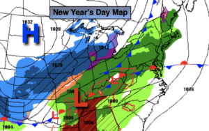
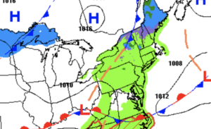
On Thursday night and Friday morning low pressure will be developing over the Southern Appalachians. This system will intensify and move rapidly off our coast by Friday morning. A period of snow is likely Thursday night into Friday morning. The storm looks to be a quick hitter (6-8 hours) which should keep any snow amounts on the low side. First call would be a 1″-3″ event with any jackpot zone being over coastal NJ and Eastern Long Island (map above).
After the snow tapers off late Friday morning the sun will return and it’ll be blustery.
Behind this system bright but cold conditions are expected for Saturday as high pressure moves in from Canada.
Low pressure and a front will move into the region on Sunday. It’ll be milder so this will predominately be a rain event.
Stay tuned..
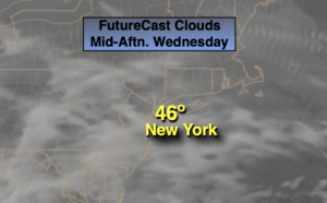
Wednesday:
A bit of light rain or freezing rain during the morning. Slick spots are possible where areas are below freezing and surfaces are untreated. Remaining cloudy. Milder. Highs in the mid 40s. South to Southwest winds at 5-10mph.
Tonight:
Clearing skies. Lows in the 30s in the City the 20s inland. Southwest to West winds at 8-12mph.
Thursday:
Mostly sunny. Seasonal. Highs around 40º.
Friday:
Early snow likely, otherwise becoming sunny and windy. Highs in the 30s.
Saturday:
Sunny. Cold. Highs around freezing.
Sunday:
Mostly cloudy. Showers likely. Highs in the lower 40s.