Synopsis:
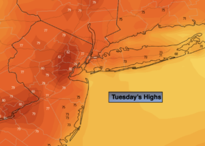
Tuesday will start with sun but clouds will roll in during the afternoon and scattered showers are possible later in the day and evening as a weak front works in from the West. High will be near the seasonal averages of 77º.
Showers are likely tonight into early Wednesday morning. The sun should return during the afternoon with typical readings for this time of the year.
A period of rain and possibly a few thunderstorms are in the forecast for Wednesday night into Thursday morning as low pressure moves swiftly through the region from the Southwest. The sun will return during the afternoon.
Friday will feature high pressure building into the region. Plenty of sunshine and warm readings are anticipated.
Saturday looks to be wet at this time as low pressure moves up the Appalachians.
Stay tuned.
Keep it here for a no hype, no nonsense forecast.
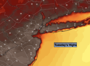
Tuesday:
Morning sun, afternoon clouds. Chance of scattered late day and evening showers. Highs in the mid to upper 70s. South to Southeast winds at 8-15mph with higher gusts.
Tonight:
Scattered showers. Lows 60º-65º. South winds at 8-12mph.
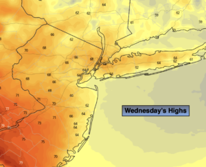
Wednesday:
Scattered showers during the morning giving way to a party sunny afternoon. Highs in the upper 70s.
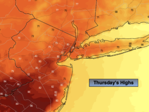
Thursday:
A chance of rain and thunderstorms during the morning. Some afternoon sun. Highs around 80º.
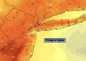
Friday:
Mostly sunny. Highs around 80º.
Saturday:
Mostly cloudy with showers likely. Cooler. Highs in the lower 70s.
Catch me on the Fox Weather Stream from 10am-2pm Friday. Find us on Tubi, Roku TV and YouTube TV and as always the Fox Weather App. It’s Free!