Synopsis:
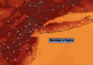
Today will be day one of what looks to be a long hot stretch of days. A bubble of hot air will work into the region as a Bermuda high sets up shop until further notice. The hottest temperatures of the season so far are expected as a heat wave grips the region. Heat Index will approach 100º Wednesday and Thursday. Scattered storms are possible late in the day Thursday as a weak front works through from the West.
The hot temperatures will stick around into the upcoming weekend.
Please take it slow outdoors. Drink plenty of fluids. Check on the elderly and pets. Listen to your body, if you feel dizzy or fatigue take a break and try to stay in air-conditioned or cooler areas.
Stay tuned.
Keep it here for a no hype, no nonsense forecast.
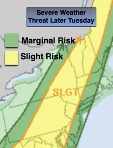
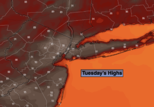
Tuesday:
Mostly sunny, hot and humid. Highs in the lower to mid 90s. West to Southwest winds at 10-15mph.
Tonight:
Mostly clear, warm and muggy. Lows in the mid to upper 70s in the City, the 60s to around 70º North and West. West winds less than 5mph.
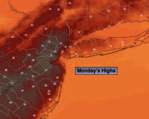
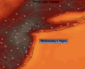
Wednesday:
Hazy, hot and humid. Highs in the mid 90s. Heat Index near 100º.
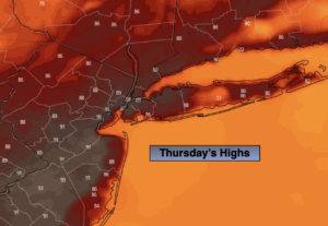
Thursday:
Hazy, hot and humid. Late day storms possible. Highs in the mid 90s. Heat Index near 100º.
Friday:
Sunny and hot. Highs in the lower 90s.
Saturday:
Sunny and hot. Highs in the lower 90s.
Catch me on the Fox Business Network this weekend until 9am Weather Stream until 10am. Find us on Tubi, Roku TV and YouTube TV and as always the Fox Weather App. It’s Free!