Synopsis:
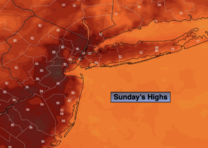
High pressure will supply a mix of sun and clouds for Sunday. It’ll be seasonable with readings in the mid 80s.
A weak disturbance both in the upper levels of the atmosphere and the surface will be responsible for unsettled weather tonight into Monday night. Scattered showers are possible late tonight and Monday morning. There will be a break in the activity and much of the late morning and afternoon should be relatively dry. Scattered storms are possible later in the day and toward evening. Temperatures will near average.
A bubble of hot air will work into the region as a Bermuda high sets up shop for mid to late week. The hottest weather of the season so far is expected as a heat wave grips the region.
Stay tuned.
Keep it here for a no hype, no nonsense forecast.
Sunday:
Sun and clouds. Highs in the mid 80s. Cooler at the coast. Southeast winds at 5-10mph.
Tonight:
Mostly cloudy. Showers possible late. Muggy. Lows in the mid 70s in the City, the 60s to around 70º North and West. Light South wind.
Monday:
Mostly cloudy with the chance of morning showers. Much of the midday to afternoon should be dry. Scattered storms possible later in the day and evening. Humid. Highs in the mid 80s.
Tuesday:
Mostly sunny, hot and humid. Highs in the lower 90s.
Wednesday:
Hazy, hot and humid. Highs in the mid 90s. Heat Index near 100º.
Thursday:
Hazy, hot and humid. Late day storms possible. Highs in the mid 90s. Heat Index near 100º.
Catch me on the Fox Business Network this weekend until 9am Weather Stream until 10am. Find us on Tubi, Roku TV and YouTube TV and as always the Fox Weather App. It’s Free!