Synopsis
Our Spring feel will continue through Thursday as the jet stream will remain well to the North keeping the cold air at bay. Temperatures through this period will be ten to twenty degrees above the average high of around 40º. In fact, on today most areas will experience readings in the 60s- balmy for sure! We’ll be flirting with the record high of 66º at Central Park.
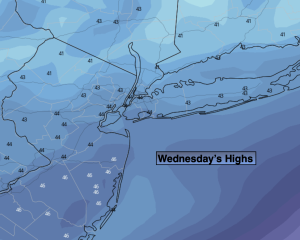
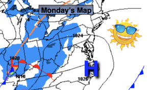
Today, ahead of the next approaching low from the South any morning fog will burn off. The sun should shine for a tine this morning. Clouds will rapidly move in thereafter. Rain is not expected until mid-afternoon. It will feel like a day out of late April with readings approaching the mid 60s in many areas.
The low will move through tonight with rain ending before midnight.
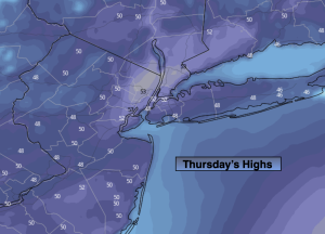
We’ll cool off on Thursday but still be well above average with temperatures. More clouds than sun is expected.
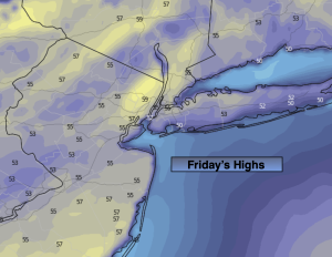
On Friday, a weak low will develop off the coast. If enough moisture is thrown back to the coast showers are possible. The trend toward cooler will continue.
The upcoming weekend looks decent still for January as high pressure moves in. Yep, you guessed it readings will be above average, by a couple degrees anyway.
Stay tuned.
Keep it here for a no hype, no nonsense forecast.
Wednesday:
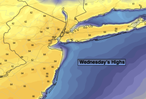
Patchy morning fog, otherwise mostly cloudy. Rain developing by mid-afternoon. Warm. Highs in the mid 60s. Southwest to South winds at 5mph.
Tonight:
Early rain, otherwise remaining mostly cloudy. Mild. Lows in the 40s throughout. Light and variable winds.
Thursday:
Mostly cloudy. Cooler. Highs in the lower 50s.
Friday:
Spot shower, otherwise mostly cloudy. Highs in the mid to upper 40s.
Saturday:
Sun and clouds. Highs in the mid 40s.
Sunday:
Sun and clouds. Highs in the mid 40s.