Synopsis
Happy New Year!
Our Spring feel will continue through midweek as the jet stream will remains well to the North keeping the cold air at bay. Temperatures through this period will be ten to twenty degrees above the average high of around 40º. In fact, on Wednesday most areas will experience readings in the lower 60s!
High pressure dominate the Eastern seaboard through today with a mix of sun and clouds.
Low pressure will move out of the Ohio Valley and toward the region Tuesday into Wednesday. It’ll be grey with on and off rain or showers just about anytime. It will not be a complete washout.
A cool front will move through on Thursday with morning showers. We should dry out by afternoon. We’ll cool off but still be a few degrees above average under a mix of clouds and sun.
On Friday, a weak low will develop off the coast. If enough moisture is thrown back to the coast rain or snow showers are possible. The trend toward colder will begin.
Stay tuned.
Keep it here for a no hype, no nonsense forecast.
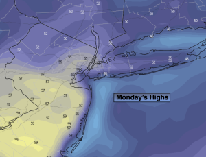
Monday:
Sun and clouds. Mild. Highs in the lower to mid 50s. West to Northwest winds at 5mph.
Tonight:
Cloudy with areas of fog. Slight chance of a shower. Lows in the 40s throughout. Light Southwest to Southeast winds.
Tuesday:
Cloudy with on and off rain or showers. Highs in the mid 50s.
Wednesday:
Cloudy with on and off rain or showers. Balmy. Highs in the lower 60s.
Thursday:
Morning showers. Some afternoon sun possible. Cooler. Highs in the upper 40s.
Friday:
Chance of rain and or snow showers. Highs in the lower 40s.