Synopsis:
Low pressure will trek from the Ohio Valley to our region Thursday. It looks to be cold enough for a mix of snow and sleet and the onset very late tonight. A minor accumulation is possible during the morning hours on Thursday. It’s not a lot of snow, but the sleet and spotty freezing rain that will fall will add to hazardous travel. The frozen precipitation will go over to rain for Thursday during the mid-morning hours. The precipitation will taper off toward Noon. Readings will pop above freezing first at the coast during the morning, then inland by midday.
The sun will return on Friday as high pressure influences the region.
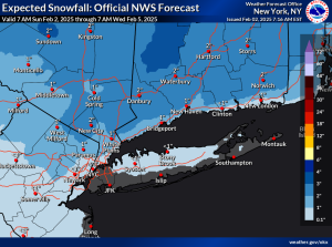
Saturday now looks to be dry. Sun will give way to increasing clouds during the afternoon. On Saturday night, another low will move toward the region from Ohio Valley. The potential exists for a mixed bag at this time. This system has the looks of its predecessor. Some accumulation is possible.
Skies should clear Sunday with readings several degrees above the average high of the upper 30s.
Monday will be sunny and colder as high pressure moves in from the Northwest.
We are in an active weather period through next week.
Stay tuned.
Keep it here for a no nonsense, no hype forecast..
Tonight:
Thickening clouds. A mix of snow, sleet and freezing rain developing toward morning. Lows around 30º in the City, the 20s inland. North to East winds at 5mph.
Thursday:
AM mix to light rain. Precipitation tapering off by midday. Highs in the upper 30s. East to Northeast winds at 5-10mph.
Friday:
Sunny. Highs in the lower 40s.
Saturday:
Sun to clouds. Potential for mixed precipitation at night. Highs in the upper 30s.
Sunday:
Clouds to sun. Milder. Highs in the lower to mid 40s.
Monday:
Sunny. Colder. Highs in the mid 30s.