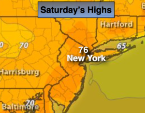
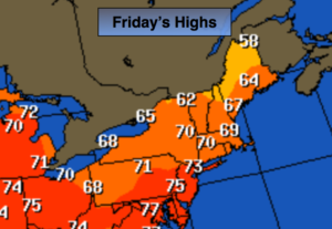
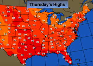
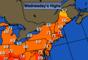
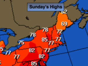
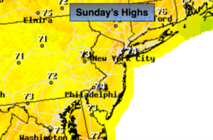
Fantastic Fireworks Forecast. A Beauty Wednesday…

Synopsis:

The weather will be fantastic for the fireworks this evening. Temperatures will be in the upper 70s under partly cloudy skies.

Wednesday will be a beauty as high pressure moves off the Northeast coast. Readings will be seasonal and the humidity will be in check.

Thursday into Friday will be unsettled with times of showers and storms as a front moves in with an area of low pressure. It will not be a washout.

The upcoming weekend looks like a gem with plenty of sunshine, warm readings and low humidity.

Tonight:

Partly cloudy. Lows in the upper 60s in the City, the upper 50s inland. Northeast winds at 5mph.

Wednesday:

Mostly sunny. Highs in the lower80s.

Thursday:

Sun and clouds. Chance of a late shower. Cooler. Highs in the mid to upper 70s.

Friday:

Mostly cloudy with scattered showers and storms. Humid. Highs in the lower 80s.

Saturday:

Mostly sunny. Highs in the mid 80s.

Sunday:

Mostly sunny. Highs in the lower 80s.

Keep it here for a no nonsense, no hype forecast.


Spot PM Storm Today. Spectacular 4th of July…

Synopsis:

Today will feature sun and clouds with just the chance of a stray late afternoon/evening storm as a trough moves through (FutureCast radar above). Humidity will be low.

Tuesday, the 4 of July will be spectacular with plenty of sunshine and seasonal readings.

If you’re headed to the beach or taking the boat out on the ocean or bay today slather on the sunscreen as the UV index is a very high 10. Please swim in guarded areas.

It’ll be seasonal with a mix of sun and clouds for the midweek period.

Have a fun and safe holiday weekend!

Today:

Partly sunny and very warm. Stray afternoon and evening storms are possible. Highs in the upper 80s. West to Southwest wind at 8-12mph.

Tonight:

A spotty early shower or storm, otherwise, mostly clear. Lows in the upper 60s in the City, near 60º inland. Northwest to North winds at 5mph.

July 4th:

Mostly sunny. Highs in the lower to mid 80s.

Wednesday:

Partly sunny. Highs in the lower 80s.

Thursday:

Sun and clouds. Highs in the lower 80s.

Friday:

Mostly cloudy with scattered showers and thunderstorms. Highs in the mid 80s.

Keep it here for a no nonsense, no hype forecast.


Rest of the Holiday Weekend-Weather Cooperates…

Synopsis:

The weather will cooperate for the rest of the holiday weekend. Today will be a much better day with mainly sunny skies. It’ll be hot, but the humidity will lower some. Weak high pressure will be over the Southeast.

Monday will feature sun and clouds with just the chance of a stray late afternoon/evening storm. Humidity will be low.

Tuesday, the 4 of July will be spectacular with plenty of sunshine and seasonal readings.

If you’re headed to the beach or taking the boat out on the ocean or bay today slather on the sunscreen as the UV index is a very high 9.  There is a moderate chance of rip currents. Please swim in guarded areas.

Have a fun and safe holiday weekend!

Today:

Mostly sunny, hot and becoming less humid. Highs near 90º. Northwest to Southwest wind at 8-12mph.

Tonight:

Mostly clear. Lows in the lower 70s in the City, the 60’s inland. West winds at 5mph.

Monday:

Sun and clouds. A stray afternoon storm is possible. Most areas will be rain-free. Highs in the mid 80s.

July 4th (Tuesday):

Mostly sunny. Highs in the mid 80s.

Wednesday:

Partly sunny. Highs in the mid 80s.

Thursday:

Sun and clouds. A spot afternoon storm is possible. Highs in the mid 80s.

Keep it here for a no nonsense, no hype forecast.


Severe T-Storm Watch for Western Areas until 9PM Sat…

Synopsis:

***Severe Thunderstorm Watch is in effect until 9pm for Western areas of the tri-state. Damaging winds and or large hail is possible within this area. Be on the look out for threatening weather. Torrential rain and frequent lightning is likely***

The weather will cooperate for much of the 4 day holiday weekend.

Sunday will be a much better day with mainly sunny skies. It’ll be hot, but the humidity will lower.

Monday will feature sun and clouds with a just the chance of a stray late afternoon/evening storm. Humidity will be low.

Tuesday, the 4 of July will be spectacular with plenty of sunshine and seasonal readings.

If you’re headed to the beach or taking the boat out on the ocean or bay today slather on the sunscreen as the UV index is a very high 10. The water will be rough and there’s a moderate to high chance of rip currents. Please swim in guarded areas.

Have a fun and safe holiday weekend!

Today:.

Hazy, warm and humid. Scattered afternoon and evening storms. Highs in the mid 80s, cooler at the coast. Southwest winds at 10-20mph.

Tonight:

An evening shower or storm otherwise, partly cloudy, warm and muggy. Lows in the mid 70s in the City, the 60’s to around 70º inland. Southwest to West winds at 8-12mph.

Sunday:

Mostly sunny, hot and becoming less humid. Highs near 90º.

Monday:

Sun and clouds. A stray afternoon storm is possible. Most areas will be rain-free. Highs in the mid 80s.

July 4th (Tuesday):

Mostly sunn. Highs in the mid 80s.

Wednesday:

Partly sunny. Highs in the mid 80s.

Keep it here for a no nonsense, no hype forecast.


4 Day Holiday Weekend Weather Cooperates (Most of the Time)…

Synopsis:

The weather will cooperate for much of the 4 day holiday weekend. Today will feature the most clouds and the best chance of showers and storms out of the 4 days. It’ll be humid as a trough approaches from the West. Keep an eye to the sky for scattered thunderstorms any time afternoon Noon. It will not be a washout. Some of the storms may be severe especially inland.

Sunday will be a much better day with mainly sunny skies. It’ll be hot, but the humidity will lower.

Monday will feature sun and clouds with a just the chance of a stray late afternoon/evening storm. Humidity will be low.

Tuesday, the 4 of July will be spectacular with plenty of sunshine and seasonal readings.

If you’re headed to the beach or taking the boat out on the ocean or bay today slather on the sunscreen as the UV index is a very high 10. The water will be rough and there’s a moderate to high chance of rip currents. Please swim in guarded areas.

Have a fun and safe holiday weekend!

Today:.

Hazy, warm and humid. Scattered afternoon and evening storms. Highs in the mid 80s, cooler at the coast. Southwest winds at 10-20mph.

Tonight:

An evening shower or storm otherwise, partly cloudy, warm and muggy. Lows in the mid 70s in the City, the 60’s to around 70º inland. Southwest to West winds at 8-12mph.

Sunday:

Mostly sunny, hot and becoming less humid. Highs near 90º.

Monday:

Sun and clouds. A stray afternoon storm is possible. Most areas will be rain-free. Highs in the mid 80s.

July 4th (Tuesday):

Mostly sunn. Highs in the mid 80s.

Wednesday:

Partly sunny. Highs in the mid 80s.

Keep it here for a no nonsense, no hype forecast.


Getaway Friday Weather Cooperates. Fairly Decent 4 Day Holiday Weekend…

Synopsis:

The heat and humidity will be high into the beginning of the holiday weekend as a Bermuda high sets up shop off the Southeast coast. June’s finale will be uncomfortable. Our first chance of a stray storm will come this afternoon or evening.

Looking at the long holiday weekend- the weather looks typical for July with warm readings and a chance of afternoon scattered storms Saturday and then again Sunday morning with a weak front moving through. It will not be a washout. Monday and July 4th looks mainly sunny and warm with lower humidity.

Stay tuned.

Today:.

Hazy, very warm and humid. A stray afternoon/evening storm is possible. Highs in the upper 80s. Southwest winds at 15-25mph.

Tonight:

An evening shower or storm otherwise, partly cloudy, warm and muggy. Lows in the mid 70s in the City, the 60’s to around 70º inland. Southwest winds at 8-12mph.

Saturday:

Hazy, very warm and humid. Spotty afternoon/evening storms are possible. Highs near 86º-90º.

Sunday:

Spotty morning storms, otherwise mostly sunny. Highs in the mid to upper 80s.

Monday:

Partly sunny. Less humid Highs in the mid to upper 80s.

July 4th (Tuesday):

Partly sunny. Highs in the mid 80s.

Keep it here for a no nonsense, no hype forecast.


Another Winner Today. Heating Up Into Holiday Weekend…

Synopsis:

High pressure will begin to build off the Southeast through weeks end. Another winner is expected today. Clouds will give way to partly sunny skies. Temperatures will come up in steps through Friday. By June’s finale (Friday) it’ll be hot once again. Our first chance of a stray storm will come Friday afternoon.

Looking at the long holiday weekend- the weather looks typical for July with warm readings and a chance of afternoon scattered storms from time to time. It will not be a washout. Monday and July 4th looks mainly sunny and warm.

Stay tuned.

Today:

Morning clouds to increasing sunshine. Breezy. Highs in the mid 80s. Southwest winds at 15-25mph.

Tonight:

Partly cloudy, not as cool as recent nights. Lows around 70º in the City, the 60’s inland. Southwest winds at 10-15mph.

Friday:.

Hazy, very warm and humid. A stray afternoon/evening storm is possible. Highs in the upper 80s.

Saturday:

Hazy, very warm and humid. A stray afternoon/evening storm is possible. Highs near 90º.

Sunday:

Hazy, warm and humid. Scattered storms. Highs in the mid to upper 80s.

Monday:

Partly sunny. Warm and humid. Highs in the mid to upper 80s.

July 4th (Tuesday):

Partly sunny. Warm and humid. Highs in the mid 80s.

Keep it here for a no nonsense, no hype forecast.


Top Ten Day Today…

Synopsis:

High pressure will begin to build off the Southeast coast today. A top ten day is expected with wall to wall sunshine and low humidity. Temperatures will come up in steps through Friday. By June’s finale (Friday) it’ll be hot once again. Our first chance of a stray storm will come Friday afternoon.

Taking a peek at the holiday weekend- the weather looks typical for July with warm readings and a chance of afternoon scattered storms from time to time. It will not be a washout.

Stay tuned.

Today:

Sunny. Low humidity. Highs around 80º. Northwest to Southwest winds at 10-15mph.

Tonight:

Clear and comfortable. Lows in the mid 60s in the City, the 50’s inland. Southwest winds at 5mph.

Thursday:

Mostly sunny. A gem. Highs in the mid 80s.

Friday:

Hazy, very warm and humid. A stray afternoon/evening storm is possible. Highs in the upper 80s.

Saturday:

Hazy, very warm and humid. A stray afternoon/evening storm is possible. Highs in the upper 80s.

Sunday:

Hazy, warm and humid. Scattered storms. Highs in the mid to upper 80s.

Keep it here for a no nonsense, no hype forecast.


Minor Hiccup Today, Then Back to a Couple of June Gems…

Synopsis:

A minor disturbance will work through the region today. There’ll be times of clouds and sun with a spotty shower or storm (FutureCast Radar above). Much of the time it’ll be dry.

High pressure will begin to build off the Southeast coast Wednesday through Friday. Temperatures will rebound by late week. By June’s finale on Friday it’ll be hot once again.

Taking a peek at the holiday weekend- the weather looks typical for July with warm readings and a chance of afternoon scattered storms. It will not be a washout.

Stay tuned.

Today:

Sun and clouds. Spotty showers and storms. Highs in the mid to upper 70s. Southwest to West winds at 10-15mph.

Tonight:

A spotty shower or storm this evening, otherwise mostly clear and cool. Lows in the lower 60s in the City, near 50º inland. Northwest winds at 5mph.

Wednesday:

Sunny with low humidity. A top ten day. Highs around 80º.

Thursday:

Mostly sunny. Highs in the lower to mid 80s.

Friday:

Hazy, hot and humid. Spotty PM Storms. Highs around 90º.

Saturday:

Hazy, very warm and humid. Spotty PM storms. Highs in the upper 80s.

Keep it here for a no nonsense, no hype forecast.


Fine Start to the Workweek…

Synopsis:

The workweek will start off pleasant. The jet stream will be flat; meaning no extremes in temperature through midweek. Highs will be just below average. The average high is 81º.

High pressure will begin to build off the Southeast coast Wednesday through Friday. Temperatures will rebound by late week.

Not much in the way of rain is expected. A stray shower or storm is possible Tuesday afternoon and then again Friday afternoon.

Stay tuned.

Today:

Mostly sunny. Highs around 80º. West to Southwest winds at 10-15mph.

Tonight:

Partly cloudy. A spotty shower is possible after midnight. Lows in the mid 60s in the City, the 50s inland. Southwest winds at 5mph.

Tuesday:

Sun and clouds. A stray afternoon shower or storm. Most areas will be rain-free. Highs in the mid to upper 70s.

Wednesday:

Mostly sunny. Highs around 80º.

Thursday:

Partly sunny. Highs in the mid 80s.

Friday:

Hazy, warm and more humid. Spotty PM storms. Highs in the upper 80s.

Keep it here for a no nonsense, no hype forecast.